Joseph and Sarah were married on January 1, 1809, in Edenbridge, Kent, England. They had nine children.
Sarah and Joseph lived in Dorking Surrey, about 20 miles west of Edenbridge. Joseph was a carpenter.
 |
Records of Revd. Thomas Hayton, perpetual curate of Long Crendon from 1821 until his death in 1887, exist.
To view the full sheet of four records, and a transcription with discussion, follow this link to the page Joseph and Sarah Come to Canada,
Follow this same link to see information on their marriage, their children, their emigration, and their new lives in Upper Canada.
Sarah died March 11, 1863. Joseph died September 7, 1877. Joseph is buried beside his wife in Avonbank Presbyterian Cemetery, in Avonbank, Perth County, Ontario.
Note: no other family members have been confirmed to date. A witness on Sarah's marriage record is named Stephen Haysman, relationship unknown at present.
Both Haysmans and the groom all signed with an X, indicating illiteracy, so the spelling on the document cannot be confirmed.
In search of the Haysman family...
2025-01-19. New thought... To find this family, perhaps use the witness, Stephen Haysman. Look for alternative spellings.
2025-03-12. Research should pick up from here.
An inquiry made of the Surrey/Kent Archives which keyed on the spelling of the name being problematic, yielded little but suggestions. (shs@surreycc.gov.uk, archives@kent.gov.uk)
When I offered up a find of a record for which I had the details but not the original, an archivist provided this image.
In the census for England and Wales, its first, taken in 1841, there is this entry...
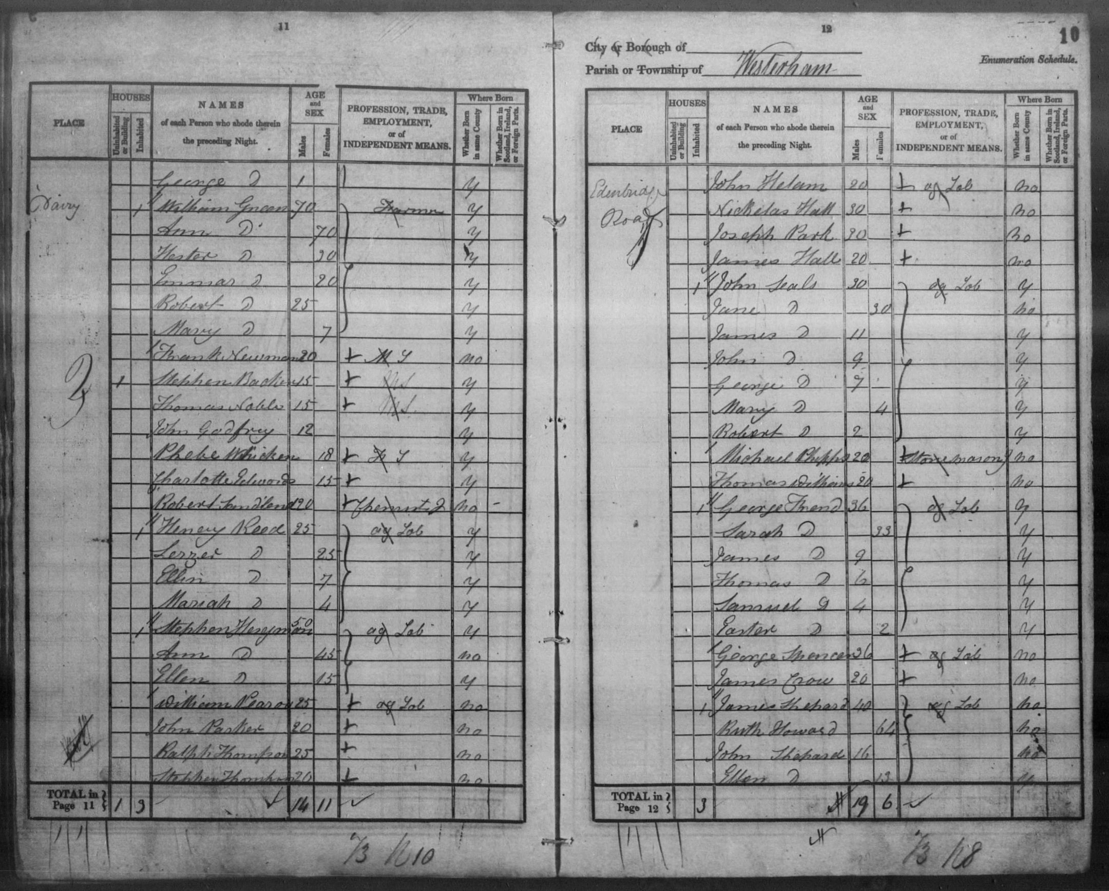 |
- Name: Stephen Hesyman..
- Age: 50*.. Birth Year (Estimated): 1791.. Birthplace: Kent.. "ag lab" (agricultural labourer)
- wife Ann Hesyman, age 45*, not born in Kent
- daughter Ellen Hesyman, age 15*, born in Kent
- Residence Place: Edenbridge Road.. Event (Census) Place: Westerham, Kent, England..
- Registration District: Sevenoaks.. Household Identifier: 2566616..
- Book Number: 13.. Line Number: 21.. Page Number: 11..
- Piece/Folio: 485/9.. Registration Number: HO107..
Archivist: "As the 1841 census was the first national census to be taken, the details that were recorded are more basic than later censuses. For instance, * - the ages of adults were rounded (note how they are all multiples of 5), so you can’t be certain if this Stephen was actually 50 or if he was younger or older than that."
"Usually in the 1841 census a double // at the beginning of an entry denotes a new household and a single / marks a separate family or individual. I therefore don't think that there is a connection between the Hesymans and the other individuals that follow (all of which look to be single men also employed as agricultural labourers). The 1841 census entries do not always clearly demarcate separate properties (the only address you have here is "Dairy", with no indication of how many properties were covered). The entry might refer to families living in a block of cottages or in separate rooms within a building. If it was a workhouse or other institution, then this would usually be indicated."
Q: Is it possible that this census entry which shows "Dairy" as the location could be referring to an actual dairy farm at which "ag lab."'s and their families could live year round at? Edenbridge, Kent, 1841.
ChatGPT said: "Yes, it's very possible! In the 1841 Census for Edenbridge, Kent, if "Dairy" is listed as the location, it could refer to an actual working dairy farm or a building associated with dairy production. Agricultural laborers (ag lab.) often lived on farms or agricultural estates where they worked, so a dairy could have housed workers involved in milk production, cheese-making, or general farm labor."
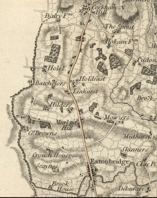
This map shows a dairy farm off Edenbridge Road, about three miles north of "Eatonbridge" (Edenbridge) and three miles south of Westerham. The left side is the border with Surrey.
Archivist, when asked about the dairy farm in a follow up question: "Yes, it certainly seems likely that the ‘Dairy’ mentioned in the 1841 census is the ‘Dairy Farm’ that appears on the 1801 Mudge map. Although other local farms may have also kept cows, the fact that ‘Dairy’ is specified suggests that the name was more significant. Subsequent entries on the opposite page are for residents living on Edenbridge Road, which runs between Edenbridge and Crockham Hill, so it would also be in the right area. It was still in existence by the time that the first detailed Ordnance Survey maps covering this area were produced c1870; you can view digitised copies of these here.
We hold some title deeds and sales particulars for Dairy Farm c1836-1837, one of which indicates that it comprised ‘house and offices and 160 acres land in Westerham’ – so a substantial farm that could have maintained a number of agricultural labourers. However, we don’t have any records relating to employees."
To locate more information, try searching for "Old Dairy Farm", "Crockham Hill Dairy Farm" or "old dairy farmhouse, Dairy Lane". Include Kent, UK and a time contraint like 1840's.
To view a modern aerial image, use Google maps. Try Streetview to see what there is to see at ground level. The farm, 160 acres, if the property was square, it would measure 0.5 miles × 0.5 miles on a map. By using the scale for this map, this would include the irregular area within the path on the south, Edenbridge Road to the east, the path to the north and the Surrey/Kent borderline to the west. If the buildings are confined to the bubble on the path, then the rest woud be graze land. Kent Brook runs through the property, the feature in the northwest quadrant of the map is likely related to it. There is an indication of modern-day Kent Farm is on the opposite side of the path from the dairy farm.
For alternative views of this area, visit Kent Heritage Maps. Views include older maps, aerial photography, and ordnance surveys.
National Library of Scotland has a map site similar to the David Rumsey collection. Locate a place then choose from the numerous maps that cover the area.
 |
Did Stephen Haysman have a son?
How this family connects...
The generations to present include :
Joseph LONGHURST / Sarah Haysman
James LONGHURST / Flora MACDONALD
Archibald John LONGHURST / Mary Martha LOOKER
Archibald Walter LONGHURST / Fannie Esther BURTON
Archibald Thomas LONGHURST / Lulu SQUIRES
Alfred Thomas Burton LONGHURST / Theresa Mary BURKE
This file last modified
: Home :